
Installing and moving projects
- One setup program installs EASy2 into one folder, with everything it needs. Updates keep your settings and your own additions.
- A project is one database file and a folder beside it. It opens quickly, even with millions of measurements, and needs no database software.
- A project set up on one computer can be installed on another with its own setup program, and finds its imagery there.
- EASy2 includes integrated Backup and Restore functions that make it easy for you to backup and restore copies of your personal projects.
- Projects made with the earlier version of EASy are converted in one step, with a report of what came across.
Imagery
- Satellite and model imagery in NetCDF, HDF4, HDF5 and GeoTIFF reads directly, with its own units and scaling.
- Ocean model output on curved grids and terrain-following layers is placed correctly, and its currents are turned to true east and north.
- The mesh output of FVCOM and DHI MIKE models shows as images, at depths below the surface and at the sea bed, without regridding first.
- Red, green and blue bands show in true color, including Sentinel-2, Landsat and NASA's daily pictures.
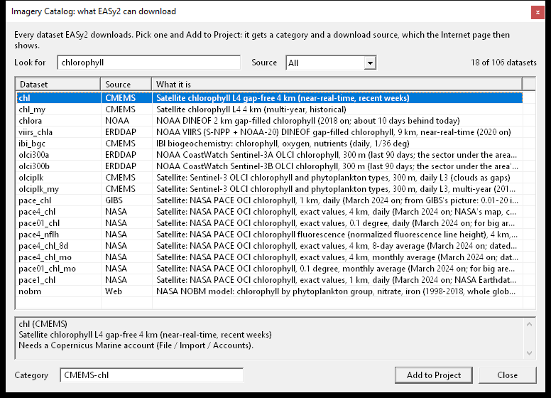
- A catalog of more than a hundred datasets from Copernicus Marine, NOAA and NASA can be automatically downloaded for any area and dates, and kept up to date on a schedule.
Analysis
- EOF analysis finds the main patterns of change in a series of images, such as El Niño in ten years of Pacific sea temperature, and carries them on to newer images.
- Merge Images averages daily images into weekly, monthly or seasonal ones.
- Image Statistics gives the mean, spread, area and volume of any part of an image, with filters on other images (only depths between 20 and 200 m, for example).
- Query Settings counts and summarizes the measurements inside an area, a range of depths and a range of dates.
- Remove Measurements takes out measurements by type, voyage, station, sensor, dates, depths or area, and keeps a backup first.
Exports and printing
- Images export as pictures (BMP, GIF, JPEG, PNG, TIFF), as NetCDF, as GeoTIFF of values for other GIS software, or as values in CSV.
- Google Earth export, with an interactive web map that opens in any web browser.
- A point's values over time come straight from Copernicus Marine or NOAA as CSV, without downloading any images.
- Image samples join station measurements and the imagery at each station into one table.
- CSV files can be written for Excel, set to US or European number formats.
- Print Report prints the map and the plots, each with its own title, size and margins.
Plug-ins
AquaModel and Spatial Analysis have moved to EASy2. Run against the earlier version on the same farms, AquaModel agrees within 0.1%. Three plug-ins are new or significantly improved: the Drifter follows drifting objects on the currents, the Tracker analyzes animal tracks, and Moving Tracks plays back ships and tagged animals along their tracks. More about the plug-ins
Help
The help covers every window and menu, with pictures, and opens in a web browser without an internet connection. A Help button or F1 opens the page about the window in front, and a search box finds every page that mentions a word.