|
|
|
|
|
|
|


 |
|||
| Product Main Page | |||
| Key Features | |||
| System Requirements | |||
| Documentation | |||
| Downloads | |||
| Support | |||
EASy 3.50
The marine GIS solution
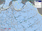
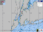
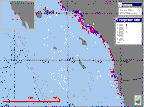
EASy is an advanced GIS with the capability to view, analyze and store diverse types of environmental data. EASy has been successfully used in a wide range of applications from resource management, mariculture, and oceanography, to pollution studies and coastal monitoring. Unlike other GIS software, EASy has been specifically designed to display data utilizing time, depth and geo-spatial information. This dynamic 4-D capability is vital for studying marine and terrestrial environments with their complex horizontal and vertical structures.
EASy's capabilities provide scientists, resource managers, companies and educators with the tools to better interpret and communicate their ideas. Experienced teams work in collaboration with users, customizing EASy to meet needs rapidly and affordably without expensive training. EASy's use in an expanding arena of projects is a testament to its versatility and the experience of our personnel.
Key Features
